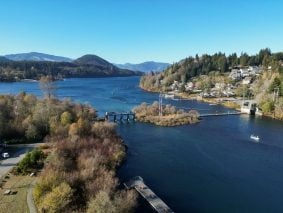
Cowichan Shoreline Assessment

Project Info
Lake Cowichan, BC
Project Services
Water Resources
Award of Merit, Natural Resource & Habitat Category, ACEC-BC (2023)
Project Highlights
With a surface area of approximately 62 km², Cowichan Lake is the second-largest lake on Vancouver Island. It drains into the Cowichan River, one of three Canadian Heritage Rivers in BC, which supports essential habitat for a range of salmonid fish species and is culturally significant to local First Nations. The Cowichan Lake Weir and associated flow control gates were constructed at the lake outlet in the 1950s and retain water in the lake during the wet spring months to maintain summer baseflows in the river downstream and support water withdrawals for the Crofton Pulp Mill.
The weir and gates manage lake levels to maintain river flow rates above established regulatory and environmental targets. However, climate change has caused a steady decline in lake inflows since the 1960s, and further declines are expected in the future. These declines make meeting the target flow rates challenging during a dry summer.
Discussion of weir upgrades began in the 1990s. Upgrade ideas include storing more water through the wet spring season by raising the weir and initiating flow regulation earlier in the season so that more water would be available to release to the river during the dry summer months. The Cowichan Lake weir is proposed to be raised by 0.7 m based on a community-led structured decision-making process known as the Cowichan Water Use Plan. Only recently, a significant barrier to action was the unknown impact on over 800 lakefront property owners.
Although the proposed raised weir operation will change lake levels by about 0.7 m for a portion of the year, this is relatively small compared to the average annual 3 m range in lake levels, which is not expected to change. Estimating shoreline impacts for such a subtle change in lake levels had never been made before. KWL developed and applied the innovative Shoreline Impacts Calculator for Changing Climates (SICCC) to the problem.
An extensive field survey and supporting desktop study identified and mapped the natural boundary location, sediment size, and vegetation classification around the approximately 110 km lake and internal islands shoreline. Computational models were calibrated to measurements to estimate the existing range of water levels and wave energy.
For analysis, the shoreline was split into 50 m along shore reaches, for a total of 2200 reaches. Regression statistics identified wave energy and water levels as the more significant contributors to the natural boundary elevation. Based on this finding, a predictive equation was developed.
Computational models with contributing factors of the weir upgrades and climate change were used to project the water levels and wave energy. The results were used along with the predictive equation to estimate the future natural boundary at all 2200 reaches.
This high-resolution assessment of natural boundary change allowed, for the first time, for shoreline impacts to be evaluated at the property level. An accompanying web-GIS tool was developed, which provides a map-based interface showing all the properties around the lake. By clicking on a property, the user is presented with a summary of the potential impacts, including flooding, inundation, changes to vegetation, and dock and beach access.
The application of SICCC to Cowichan Lake has provided a basis for public engagement and shoreline property owner consultation as part of regulatory approvals. As a result, the process has removed a significant barrier to climate action for the Cowichan community.
Key Contact(s)
Crystal Campbell Senior Project Manager
Clayton Hiles Coastal Engineer
Craig Sutherland Water Resources Engineer
Eric Morris Branch Manager (Vancouver Island)
Ryan Taylor GIS Coordinator


